Upland Cultural Landscapes
Echoes from the Uplands
New archaeological observations and discoveries within Appalachian upland landscapes site settings, signatures, and the significance of these findings to the public and to ancestral Tribes.
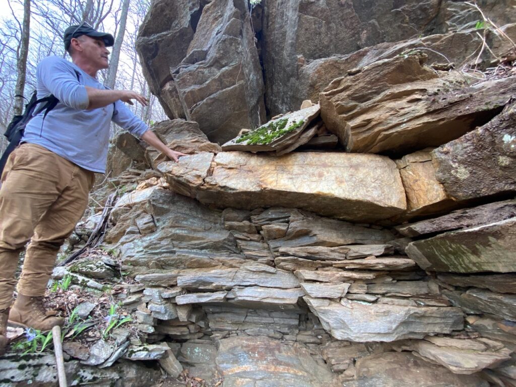
What Is a Native Quarry?
- A site where Native/Indigenous peoples extracted raw rock or mineral material for human use.
- Raw materials were then processed in adjacent quarry workshops.
- Uses included projectile points, edged tools, quarrying picks, hammerstones, anvils and wedges.
- Native-quarried materials were traded widely across the Americas.
Pre-European Stone Quarries
Ancient Cultural Impacts & Landscape Alteration
Explore an array of Appalachian pre-European quarries, many scattered across upland landscapes at varying elevations. As Dr. Philip LaPorta of the Center for the Investigation of Ancient and Native Quarries (CINAQ) explains, these significant site types offer unparalleled insights into the sophisticated resource extraction and technological prowess of ancient peoples — demonstrating a rich history of engineering and collective labor long present before the arrival of Europeans. The scale and complexity of these quarries can be breathtaking, and their archaeological contexts are critical for understanding large-scale Native American resource extraction.
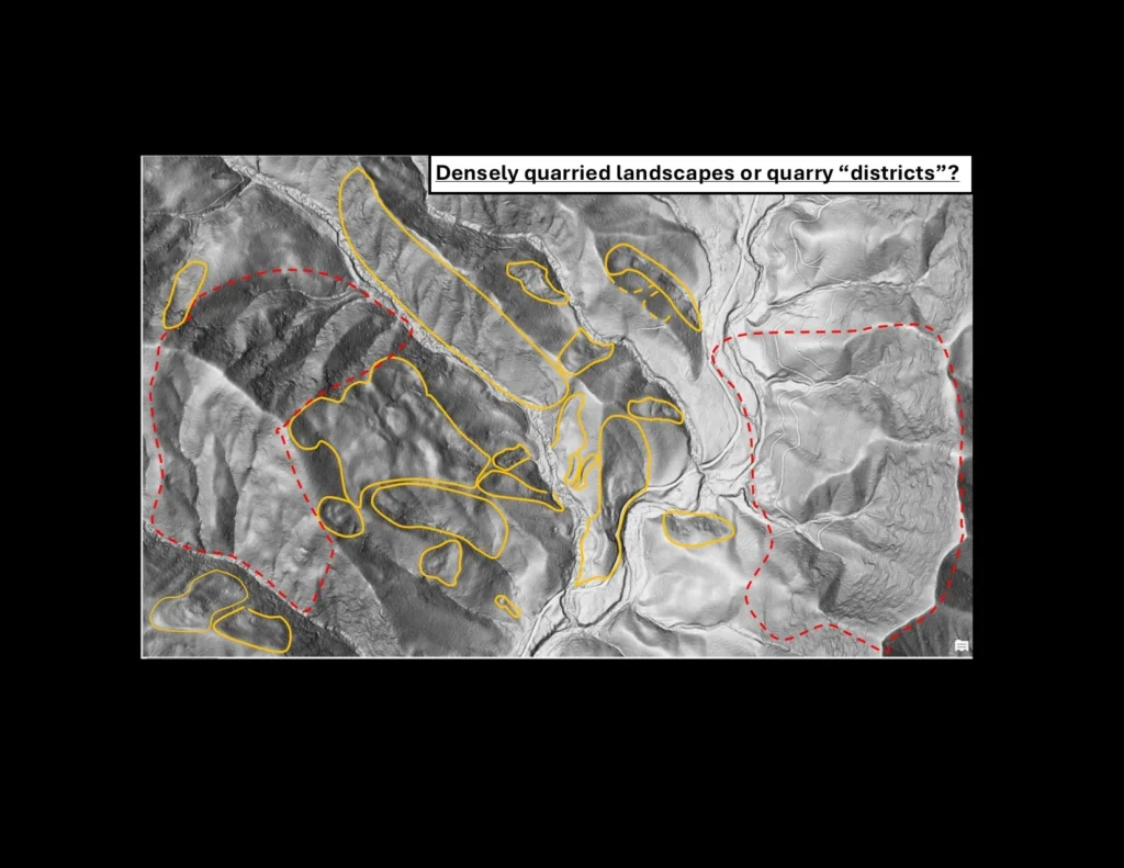
LiDAR Imagery Analyses
Reading the Landscape From Above
Western North Carolina LiDAR hillshade imagery reveals a possible large pre-European quarrying landscape, where local geologic conditions produced outcrops of high-quality “milky” quartz. Clusters of potential quarry-zone signatures were identified through image analysis and extensive field reconnaissance by Ashcraft, Sas, LaPorta, Minchak and Kimball (2022–2025).
Variation in landscape-signature characteristics may reflect differences in underlying geology. Some polygons mark areas with intermittent or ambiguous signatures that have not yet been field verified.
Identifying and evaluating these zones is best accomplished by a multidisciplinary team — LiDAR specialists, upland geomorphologists, bedrock geologists, soil scientists, and archaeologists — examining features collectively, cross-checking, and interpreting only when integrated evidence supports it.
Section Under Construction
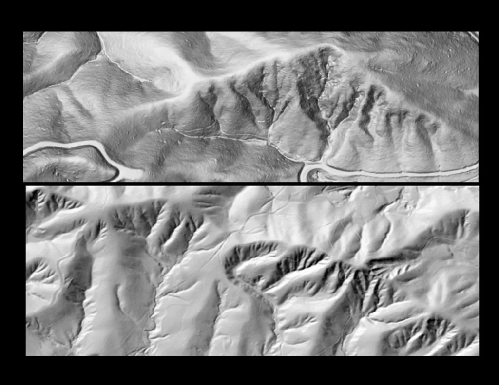
Distinct Quarrying Landscape Signatures
Preliminary observations suggest that the impressions left by extensive quarrying are a direct result of the underlying geology — how a stone formation is positioned and how its lineation or folding sits within the bedrock. Metamorphosed, folded and stretched rock types such as mylonitized quartz produce distinctive extraction patterns that either follow highly accentuated natural drainages, or whose trenches mimic deeply entrenched dendritic patterning. In these settings, it is hypothesized that rainwater was channeled through multiple trenches to assist overburden removal (Ashcraft and Sas 2025).
Historic-Period Features
Recent Quarrying & Mining Signatures
LiDAR hillshade imagery shows the distinctive landscape signatures that result from historic-period quarrying or mining — operations from the age of powered machinery and vehicles, usually easily discernible from maps and imagery.
They are recognized by dramatic, deeply excavated features: long trenches, vertical shafts, or adits extending horizontally into sloping terrain. These modern operations are typically surrounded by road cuts and skid-trails that extend up or down adjacent slopes to formal roadbeds.
Historic-era operations very often overprint or destroy much earlier Native American quarrying or mining sites — earlier efforts that remained visible on the landscape, such as mica-mining signatures, and were easily recognizable during historic prospecting.
Continue Exploring
A World of Archaeology Where No One Was Looking
Dive deeper into how shifting paradigms in Appalachian archaeology — informed by LiDAR, Tribal knowledge, and field reconnaissance — are rewriting what we thought we knew about these mountains.